The Upper Rappahannock River Mapping Project: The Civil War in Culpeper and Fauquier Counties, 1862-1864 documents the broad and complex historical landscape that extends across much of Virginia’s Culpeper and Fauquier Counties, anchored along the Rappahannock River. During 1862-1864, nine battle engagements – including Cedar Mountain – took place in this area, and its strategic importance during the Civil War is supported by this report’s in-depth analysis that includes a wealth of current resources as well as historic photos and maps. An excellent resource for anyone interested in learning more about the historical landscape of Culpeper and Fauquier Counties.
Click on the image below to read the full report on issuu.com
Much of the history of Raccoon Ford that is discussed relates to the Civil War, but the area also may have played a role in our country’s early history. Ron Vecchioni, who is currently renovating historic St. Paul’s Church in Raccoon Ford, shared the following information:
It was the Marquis de Lafayette’s stop here in the spring of 1781 that earned the hitherto unnamed ford across the Rapidan River its name. While waiting for additional forces to join him, Lafayette directed his troops to begin cutting down trees to build ramps on either bank of the Rapidan River, to aid in moving their supply wagons and cannons across the shallowest point in the river.
As his troops began cutting down nearby trees for construction of the ramps they came to a tree with a mama raccoon and her kit of babies. There are two versions of the events that transpired there. In one version the tree is unceremoniously cut down and the raccoons scampered across the river, hence the name Raccoon Ford.
In the other version, a heated argument breaks out, as Lafayette, who has never seen raccoons before, directs his men to leave the animals unmolested and instead cut down another tree a further distance away from the river. This of course meant more physical labor for the troops.
Who knows which version is the truth? It is however safe to say that there was a tree, there were raccoons in it, and Lafayette was there.
Thus Raccoon Ford was the springboard for the final campaign of the American Revolution. It was here that Lafayette’s 1,000 Continental soldiers and 2,000 New York Militia waited for “Mad” Anthony Wayne’s Army to join up. Wayne arrived with an additional 800 Pennsylvania Continentals on June 10, 1781. A few days afterwards, William Campbell’s force of 1,000 additional militia gathered from southwestern Virginia arrived.
With a sizable force of over 4,500 armed men, Lafayette now was strong enough to march towards and confront Cornwallis who was advancing up the Virginia peninsula towards Richmond, Virginia. At Yorktown Lafayette was joined by a Continental Army led by General George Washington along with French Army troops led by the Comte de Rochambeau. The combined land force encircled Cornwallis and laid siege to Yorktown. With the help of the French Navy blockading the Chesapeake Bay from the British Navy, Cornwallis had no choice but to surrender on October 19, 1781.
The Yorktown campaign was the last major land battle of the American Revolutionary War. The defeat of Cornwallis and capture of his entire army prompted the British government to negotiate an end to the conflict. The 13 colonies had finally won their independence and the United States of America was created, and the whole thing began at a little unnamed river crossing on the Rapidan River now known as Raccoon Ford in southern Culpeper County, Virginia.
On June 30, 2019, the Culpeper Star Exponent published an article describing the impact a proposed 1300-acre utility-scale solar project would have on the antebellum properties surrounding Raccoon Ford.
An excerpt:
RACCOON FORD—Before war came, Congressman and secessionist Jeremiah Morton designed three mansions along a few miles of Algonquin Trail in southern Culpeper County.
The stately homes withstood armies’ fighting, encampment and occupation during the Civil War, and still stand today. Restored by their owners, they have storied pasts and anchor former plantations near the Rapidan River, named by a Colonial governor for Queen Anne of England.
Farmland surrounds the graceful houses—Greenville, Struan and Sumerduck—in an area on the Rapidan that’s mostly untouched by time and steeped in early history, including that of Indians and African-Americans. The countryside also yields many accounts from the War Between the States.
“Where else in the country do you have a Civil War laboratory like this? Nothing has changed,” Civil War historian Clark “Bud” Hall said during a visit to the mansions of Algonquin Trail.
Change could be coming, though, as county officials consider allowing a utility-scale solar plant to be built on 807 acres of agriculturally zoned parcels along the rural route.
Cricket Solar LLC, the project’s developer in Irvine, California, says the green initiative will generate enough electricity to power 15,000 homes a year.
The Culpeper County Planning Department is reviewing revisions to an application submitted in December by Cricket that would place more than 270,000 solar panels in the Raccoon Ford area.
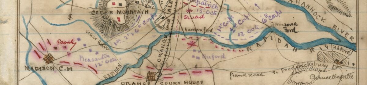
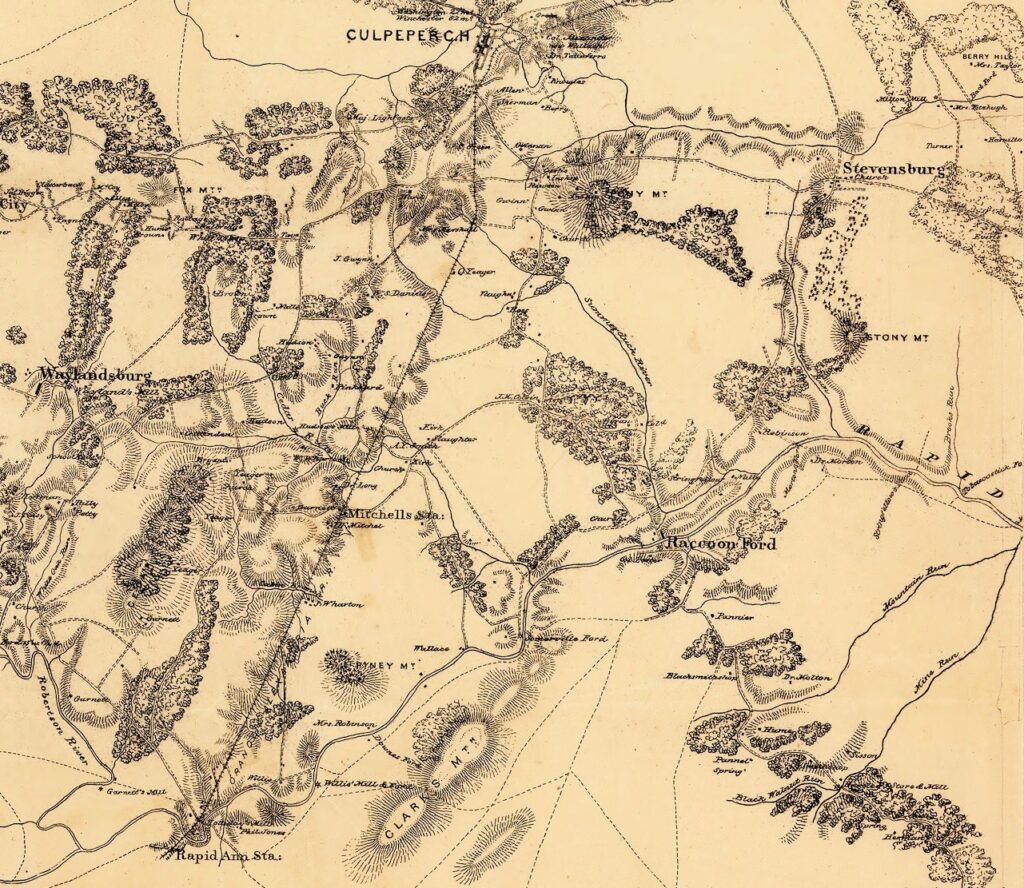
Clark B. “Bud” Hall is a historian and preservationist who has written widely on the role of cavalry in the American Civil War. In 2012 he received the Civil War Trust’s “Lifetime Achievement Award,” in recognition of his 25-year efforts to protect America’s hallowed ground. He is an expert in the history of the Civil War in Culpeper County and is a frequent contributor of articles on local history to the Culpeper Star Exponent. Hall shared the map below with the following comments:
This 1864 map by Captain William H. Paine depicts the still-pristine territory along the Rapidan River near Raccoon Ford. On the lower left, the confluence of the Rapidan and Robinson (Horseshoe) rivers is seen just beneath “Garnett’s Mill.” Fifteen miles to the east, downriver, Mine Run enters the Rapidan.
In the center-right of this superb military map, Raccoon Ford is shown in bold script by the mapmaker and he did that for the ample reason that Raccoon Ford is the single most significant ford on the Rapidan Front.
Note the mapmaker has highlighted Robinson (now Struan); Nalle (now Greenville); and Stringfellow (Summerduck) – all historic properties that continue to thrive in the Raccoon Ford area. Morton’s Ford, site of a February 1864 battle, is situated just beneath Robinson.
The officer who created (and field-checked) this map, Captain William Paine, was the top mapmaker in the Army of the Potomac. After the Civil War, Captain Paine, an engineer, built the Brooklyn Bridge.